SALTMOD

and Examples of Application

SaltMod is a computer program for the prediction of the salinity of soil
moisture, ground and drainage water, the depth of the water table,      
and the drain discharge in irrigated agricultural lands, using
different (geo)hydrologic conditions, varying water management
options, including the reuse of ground water for irrigation,
and several cropping/irrigation rotation schedules.
The simulation model uses hydrologic balances and drainage
equations to define the depth of the water table.
Capillary rise is one of the factors that can influence the soil salinity.

R.J.Oosterbaan
ILRI, Wageningen, The Netherlands

May 2002

On web site www.waterlog.info

for free downloads see the SaltMod page

Category
selection:

SahysMod
page

software
& models

articles
& manuals

reports
case studies

FAQ's
& answers

home
page
 

TABLE OF CONTENTS

1. INTRODUCTION
1.1. General
1.2. Rationale

2. PRINCIPLES
2.1. Seasonal approach
2.2. Hydrological data
2.3. Agricultural data
2.4. Soil strata
2.5. Water balances
2.6. Drains, wells, and re-use
2.7. Salt balances
2.8. Farmers' responses
2.9. Annual input changes
2.10 Output data
2.11 Other users' suggestions

3. WATER BALANCE EQUATIONS
3.1. The reservoir concept
      3.1.1. The surface reservoir
      3.1.2. The root zone
      3.1.3. The transition zone
      3.1.4. The aquifer
      3.1.5. Top soil water balance
      3.1.6. Sub-soil water balance
      3.1.7. Agronomic water balance
      3.1.8. Geo-hydrologic water balance
      3.1.9. Overall water balance
3.2. Model calculations for water balances
3.3. Capillary rise and actual evapo- transpiration                                          
      3.3.1. Depth of the water table and capillary rise factor
      3.3.2. Potential evapo-transpiration and moisture deficit
      3.3.3. Apparent capillary rise and actual evapo- transpiration
      3.3.4. Capillary rise
3.4. The subsurface drainage
3.5. Water balance of the transition zone
3.6. Irrigation efficiencies and sufficiencies

4. SALT BALANCE EQUATIONS
4.1. Change in salt content
4.2. Salt balances under full cropping rotation
      4.2.1. Above the soil surface
      4.2.2. Root zone
      4.2.3. Transition zone
      4.2.4. Aquifer
      4.2.5. Salt concentration of drain and well water
4.3. Salt balances under zero cropping rotation
      4.3.1. Above the soil surface
      4.3.2. Root zone
      4.3.3. Transition zone
4.4. Salt balances under intermediate cropping rotations
      4.4.1. Types of cropping rotation
      4.4.2. Part of the area permanently non-irrigated, Kr=1
      4.4.3. Part of the irrigated area permanently under A crop(s)
      4.4.4. Part of the irrigated area permanently under B crop(s)

5. AREA FREQUENCY DISTRIBUTION OF SOIL SALINITY

6. FARMERS' RESPONSES
6.1. Reduction of irrigated area when salinization occurs
6.2. Reduction of irrigation when water logging occurs
6.3. Reduction of ground-water abstraction by pumping from wells     

7. ALPHABETICAL LIST OF ALL SYMBOLS USED

8. USER MENU
8.1. The main menu
      8.1.1. The input menu
      8.1.2. Calculations
      8.1.3. The output menu
8.2. Editing the input
8.3. Inspecting the output
      8.3.1. Soil salinities root zone
      8.3.2. Other salinities
      8.3.3. Drain/well flow, water table
      8.3.4. Percolation
      8.3.5. Capillary rise
      8.3.6. Canal/field irrigation, bypass
      8.3.7. Irrigation sufficiencies/efficiencies
      8.3.8. Crop area fractions, rotation key
      8.3.9. Scroll through the entire output file

9. LIST OF SYMBOLS OF INPUT DATA

10 LIST OF SYMBOLS OF OUTPUT DATA

11 CASE STUDY EGYPT
11.1. Introduction
11.2. Calibrating the leaching efficiency
11.3. Determining the natural subsurface drainage
11.4. Simulating effects of varying drain depths
11.5. Reconstructing the initial conditions

12 CASE STUDY INTERACTIONS
12.1. Introduction
12.2. Irrigation efficiency, sufficiency
12.3. Irrigation and soil salinity
12.4. Conclusion

13 REFERENCES


saltmod uses three
           irrigation areas SaltMod uses a rootzone layer, a transition zone (in which the drains are situated), and an aquifer.

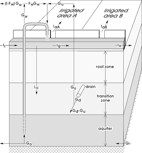
SaltMod calculates water and salt balances including the reuse of groundwater by pumping from wells.
It also calculates the capillary rise from the depth of the water table and the shortage of irrigation water compared to the evaporation.
The subareas with different cropping patterns can influence each other by transport of water through the aquifer.
The soil salinity is derived from the balance of incoming and outgoing salts.
Farmers responses to changing soil conditions can be evoked.