1. Agricultural drainage
criteria
|
|
This is a book chapter dealing with drainage
systems,
effects on agriculture, design criteria and examples
in various agro-climatic zones.
The table of contents
may be viewed here.
|
2. Data analysis in drainage
research
|
|
This is a lecture note with examples of application
of four software packages on this web site
(CumFreq, SegReg, EnDrain and RainOff) and
other analysis topics.
View table of contents
here.
|
3. Energy balance of
groundwater flow
|
|
This is copy of an article published earlier. It
gives physical theory of groundwater hydraulics.
View abstract.
|
4. Application of the energy
balance of steady state groundwater flow to
pipe drains and ditches
|
|
This is an article (view
abstract) giving
the mathematical theory and examples
of groundwater movement and seepage
used in the EnDrain program, see below.
For comparison, an article on both steady and
non-steady state drainage, using both the
EnDrain and RainOff software, see below,
can be read
over here
|
5. Well spacing
equations for subsurface drainage of
agricultural land by pumped wells
|
|
This paper can be used as a manual of the
WellDrain program (see Software page).
For information on well pumping tests for aquifer
properties visit the same page.
|
6. Determining hydraulic
conductivity of soils
|
|
This is a book chapter dealing with the
determination of the saturated hydraulic
conductivity of soils using small and large scale
methods
The table of contents may
be viewed here.
|
7. SaltMod manual
|
|
This manual gives a description of the Saltmod
model (see Software page or below) including its
principles, user menu, and case studies.
See table of contents
|
8. SahysMod manual
|
|
This manual gives a description of the SahysMod
model (see Software page or below)including its
principles, user menu, and case studies
SahysMod is a combination of Saltmod and a
mathematical (numerical) groundwater model
simulating water flow and salinity in unconfined
and semiconfined (leaky) aquifers using a
polygonal network with nodal points.
See table of contents
|
9. Subsurface drainage
equations using the full energy balance
of
groundwater flow in
layered and/or anisotropic soils.
|
|
This is an article on the use of the steady
state
EnDrain model
for subsurface land drainage published in
the International Journal of Research in
Agriculture and Forestry. For comparison
an article on both steady and non-steady
state drainage, using both
EnDrain and
RainOff can be
read
over here
|
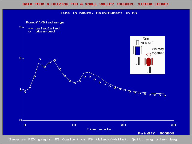
9. Rainfall-runoff
relations of a small valley
|
|
This is an article on the use of the
RainOff model for
the rainfall-runoff relations in a small
valley in Sierra Leone published in the
International Journal of Environmental
Science.
|
|
|
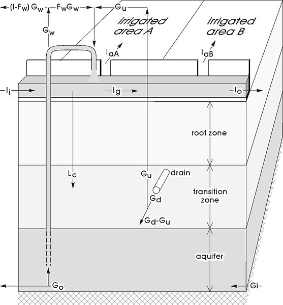
Water balance factors in
SaltMod and
SahysMod
|
|
|
Example of results of the RainOff model simulating
runoff.
|
|
OTHER
CATEGORIES:
All
software
& models
All
articles
& manuals
All published
reports
& cases
All particular
reports
& cases
All
FAQ's
& papers
Update
record
Contact
form
Home
page
|
B) - Free software and models
RainOff
helps in modelling effective rainfall, recharge, water
storage, runoff, drainage and discharge relations in
hydrological catchment areas (watersheds) using
the concept of a nonlinear reservoir.
EnDrain
does calculations on horizontal subsurface drainage
systems in agriculture, hydraulic head, depth and level
of water-table in agricultural land, and drain spacing
using the energy balance of groundwater flow but also
the Darcy and continuity equation (mass balance of
water). It includes drain entrance resistance and soil
anisotropy of hydraulic conductivity (soil permeability
for water), i.e. the horizontal and vertical hydraulic
conductivity are different. Applicable to pipe/tile
drains (drain pipes) and open ditches.
WellDrain
Calculates the spacing of wells, the shape, depth, and
level of the watertable in vertical drainage systems
using pumped wells. Like EnDrain, it permits aquifers
with various different properties and, in addition,
fully/partially penetrating wells.
SaltMod
a mathematical, numerical simulation model describing
the relations between agriculture, crop rotation,
irrigation, rainfall, potential and actual,
evaporation (evapotranspiration), climate,
hydrology, depth and level
of water-table, capillary rise, deep percolation, soil
salinity and subsurface drainage by drains or wells, and
reuse (conjunctive use) of ground and drain water from
wells. It includes farmers' responses to water logging
and soil salinity.
SaltCalc
A simplified version of SaltMod with the advantage that
calculations can be made for shorter time steps (e.g.
weekly or monthly). SaltCalc can be used when field
observations of irrigation, water table and soil
salinity have been made and one wishes to develop a
model for that situation. Normally, calibration of
unknown values must be done using a range of values of
the corresponding variable, running the model
repeatedly for a number of time steps, and
selecting from the range
the value giving model results closest to observed
values as the optimal value.
LeachMod
This model is somewhat similar to SaltCalc. On the one
hand the water management options are fewer (e.g.
re-use of drainage or well water for irrigation do not
feature here), but the model is more modern in the
sense that the variable input for each time step is
given in a table so that the calculations over all
the time steps are done in one go. Moreover, by
inserting the observed values of soil salinity in
the data table, the model optimizes the leaching
efficiency of the soil.
SahysMod
a combination of Saltmod with a model of ground water
flow and hydraulics to account for large spatial
variation through a network of polygons. It includes
phreatic (unconfined) aquifers as well as soil layers
with slow vertical hydraulic conductivity (soil
permeability for water) resulting in semiconfined
(leaky) aquifers.
|
All
software
& models
All
articles
& manuals
All published
reports
& cases
All particular
reports
& cases
All
FAQ's
& papers
Update
record
Contact
form
Home
page
|
C) - Frequently asked questions
|
|
Depth of the watertable and crop production, field
data
|
|
|
1a - What is waterlogging? (This is probably the most
frequently asked question)
|
|
In agriculture, waterlogging means that the soil is
considered too wet to cultivate crops profitably
(except lowland rice).
Waterlogging can be stagnation of water on top
of the soil surface and/or the presence of
a high water table inside the soil (at a
depth of say 0.7 m on average).
Surface waterlogging can be seen as a flood
control problem or a surface drainage
problem.
Subsurface waterlogging can be tackled by a
subsurface drainage system.
As an alternative one may opt for another kind of
land use.
More information can be found in an article on
Drainage Criteria
and in a paper on world wide cases of
Drainage
Systems.
See also
Wikipedia (watertable control)
|
1b - Why is soil drainage required for plant growth?
(Also a very frequently asked question)
|
|
Drainage is required when the soil is too wet
(waterlogged) for optimium crop growth. Then, the
soil needs to be made dryer by drainage.
There is a series of reasons why crop growth is
hampered in waterlogged conditions.
The article on
Agricultural Drainage criteria explains some of
the mechanisms and gives examples of crop response
to waterlogging and yield increase with drainage
(chapter 17.4).
Other examples of crop responses to drainage can be
found in: Drainage
reseach in farmers' fields
|
|
2 - What kind of drainage systems are applicable under
what conditions?
|
|
It is difficult to give a generally valid answer to
this question, but the paper on surface and subsurface
drainage systems
gives a summary of practical experiences with
different methods under varying agro-climatologic
conditions.
|
3 - How can I calculate drainage discharge needs and
irrigation/leaching requirements for salinity control
using water and salt balances without resorting to
simulation models like SaltMod and SahysMod?
|
|
It is difficult to give a generally valid answer to
this question, but the paper on surface and
subsurface drainage
systems gives a summary of practical experiences
with different methods under varying
agro-climatologic conditions.
|
4 - What is the influence of land slope on the spacing
of subsurface drains?
|
|
The answer is: for drain spacing calculations the
slope of the land has little influence. For this
purpose, sloping lands may considered as if they
were flat.
This is a paper with
mathematical explanations
|
5 - How can hydraulic conductivity (permeability) of
the soil be measured and determined?
|
|
The measurement of hydraulic conductivity can be
done in the laboratory or in the field, above or
below the water table, using small scale (auger
hole method, infiltration method) and large scale
methods (e.g. using drainage data in existing
experimental fields or in farm land).
A full description is given in the chapter
"Measurement of hydraulic
conductivity of soils".
See also the table of
contents on line.
For well pumping tests to determine aquifer
hydraulic properties see the WellDrain model
(software page).
|
6 - Drain spacing equations for horizontal tile/pipe
drains are well known. Can subsurface drainage also be
done by (tube)wells and how can the required
spacing be calculated?
|
|
The calculation of well spacings for subsurface
drainage can be done with the WellDrain program
(see software page). The theory behind it is
discussed in the paper
Well spacing equations.
For well pumping tests to determine aquifer
hydraulic properties see the WellDrain model
(software page).
|
7 - What is the optimimum depth of the water table and
how can we develop suitable drainage criteria to
design a subsurface drainage system
|
OTHER
CATEGORIES:
All
software
& models
All
articles
& manuals
All published
reports
& cases
All particular
reports
& cases
All
FAQ's
& papers
Update
record
Contact
form
Home
page
|
|